Pages

Famous Temple Sri Lakshmi Narasimhaswamy Temple Mangalagiri and Mangalagiri cotton sarees


Mangalagiri  is a town, and a mandal of Guntur District of Andhra Pradesh, India.It is situated on the Guntur-Vijayawada road, 8 miles (13 km) to the south-east of Vijayawada and 13 miles (21 km) to the north-east of Guntur.Mangala means The holy Giri means hill Mangalagiri means The holy hill in Telugu Subhapradamaina konda Area of the town is 10.49 square kilometers and Population 2,31,981 

About 200 Years back Raja Vasireddy Venkatadri Naidu who was well known and who ruled from Amaravathi as his capital constructed a stupendous gopuram (tower) on the eastern gate of the lower temple of Lakshmi Narasimhaswamy. It is one of the highest gopurams in South India and only one of its type in this part of India. It is 125 ft. in height with 11 storeys and gates facing east and west. This great and imposing tower dwarfs the central shrine

Higheat Gopuram in South India (old photo)

Gopuram (Tower) in lighting

Devotees pulling the chariot of
 Sri Lakshmi Narasimha Swamy during ‘Rathotsavam' 

Lord Sree Lakshmi Narasimhaswamy
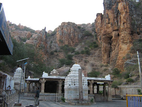
Panakalaswamy&Narasimhaswamy Temples

Mangalagiri Panakala Swamy

Mangalagiri is also famous for cotton sarees (Mangalagiri ctton)

In Saree making process

Beauty of Mangalagiri cotton saree

Mangalagiri cotton saree

Most Powerful Electric Fish in the World "Electric Eel"


World most powerful fish is the ' electric eel '.They are found in Amazon rainforest in rivers of Brazil, Columbia, Venezuela, and Peru. They prefer to live on muddy bottoms in calm fresh water and in stagnant rivers with fresh water. The electric eel will grow to about 2 meters  and weigh about twenty kilogram’s. The mouth of electric eel is square and the fish looks more of a serpentine. Its body is round and more than 85% of that body is the tail. The fish has gills alright but the fish is an obligate air-breather – meaning that every now and then it will keep on rising to the surface to gulp air before returning to the bottom of water. The electric eel has no scales like other fishes. The electric eel feeds on other fishes, amphibians, crabs, birds and small mammals that may find their way into water.

The electric eel is electrogenic meaning it can generate electric fields. The electric eel is also electroreceptive meaning it can detect electric fields from enemies. The electric eel will generate upwards of 500 volts of electricity if disturbed by an enemy. But voltage is nothing without a current. The electric eel will also generate a current of 1amp. This power is a lethal discharge that can cause cardiac failure in large preys like human resulting in instant deaths. It is because of this that the electric eel can claim to be the king of the under water.

What is the Mystery of "Bermuda triangle" or " Devil's triangle" ?

The Bermuda Triangle /the Devil's Triangle is a stretch of the Atlantic Ocean bordered by a line from Florida to the islands of Bermuda, to Puerto Rico and then back to Florida. It is one of the biggest mysteries of our time - that perhaps isn't really a mystery.
The term "Bermuda Triangle" was first used in an article written by Vincent H. Gaddis forArgosy magazine in 1964. In the article, Gaddis claimed that in this strange sea a number of ships and planes had disappeared without explanation. Gaddis wasn't the first one to come to this conclusion, either. As early as 1952, George X. Sands, in a report in Fate magazine, noted what seemed like an unusually large number of strange accidents in that region.
In 1969 John Wallace Spencer wrote a book called Limbo of the Lost specifically about the Triangle and, two years later, a feature documentary on the subject, The Devil's Triangle, was released. These, along with the bestseller The Bermuda Triangle, published in 1974, permanently registered the legend of the "Hoodoo Sea" within popular culture.
Why do ships and planes seem to go missing in the region? Some authors suggested it may be due to a strange magnetic anomaly that affects compass readings (in fact they claim Columbus noted this when he sailed through the area in 1492). Others theorize that methane eruptions from the ocean floor may suddenly be turning the sea into a froth that can't support a ship's weight so it sinks (though there is no evidence of this type of thing happening in the Triangle for the past 15,000 years). Several books have gone as far as conjecturing that the disappearances are due to an intelligent, technologically advanced race living in space or under the sea.

Ring of Fire /Pacific Ring of Fire the active Volcanic Zone

The area encircling the Pacific Ocean is called the "Ring of Fire," because its edges mark a circle of high volcanic and seismic activity (earthquakes). Most of the active volcanoes on Earth are located on this circumference.The Ring of Fire has 452 volcanoes and is home to over 75% of the world's active and dormant volcanoes. It is sometimes called the circum-Pacific belt or the circum-Pacific seismic belt.About 90% of the world's earthquakes and 80% of the world's largest earthquakes occur along the Ring of FireThe Ring of Fire is a direct result of plate tectonics and the movement and collisions of lithospheric plates


Ring of Fire

Volcanic Eruption of Mount St. Helens

SreSailam


   Lord Shiva
Srisailam  is a holy town and mandal, situated in Nallamala Hills of Kurnool district, Andhra Pradesh, India. It is located on the banks ofRiver Krishna, about 232 km south of Hyderabad.
Bhramaramba Mallikarjunaswamy Temple dedicated to Lord Mallikarjuna Swamy (a form of Shiva) and Devi Bhramaramba (a form of Parvathi) is located here and it is one of the 12 Jyotirlinga temples dedicated to Lord Shiva. Srisailam Dam, located about 245 km from Hyderabad and 132 km from Nandyal, is a multipurpose dam has been built across River Krishna and caters to the irrigation and power needs of the state.
    Srisailam Dam

   River Krishna


    Rope way


Telugu actress Anushka


   Bommali Anushka acted film Arundhathi Palace

                              
    Actress Anushka                                          

Science Exhibition


  SCIENCE FAIR AT Z.P.HIGH SCHOOL,PEDAKONDURU 


    Young Scientists with their experiments                                   
                                                               

   Volcanic eruption


Ahobilam,Kurnool district


                                                              Ahobilam
                          
                               Ahobhilam also known as Ahobalam is located in the Allagadda mandal of Kurnool district in Andhra Pradesh,India. It is located at a distance of 40 km from Nandyal and about 150 km from Kurnool, the district headquarters.
It is a major pilgrimage site in South India and is one of the 108 Vaishnava Divyadesams. According to the legend, this is where Lord Narasimha blessedPrahlada and killed the demon Hiranyakashipu.
                             
    Main Entrance to Temple                 


ISHTA KAMESWARI DEVI TEMPLE,SRISAILAM


  ISHTAKAMESWARI DEVI TEMPLE AT SRISAILAM
                                            The temple is inside a cave and is at a distance of about 21kms from the main temple in the thick NALLAMALA forest. The goddess here ‘Ishtakameshwari’ is another name of Goddess Parvati.
Believed to be constructed during 8th – 10th century this temple is very popular with the locals and the tribals. Another unique feature of the temple is that the forehead of the idol feels like that of a human skin

     ISHTA KAMESWARI DEVI TEMPLE ENTRANCE 


     Tribal hut at Ishtakameswari Devi Temple


Yaganti Sree Uma Maheswara Temple / Yaganti Caves(Guhalu)


Yaganti Sree Uma Mheswara Temple/ YAGANTI CAVES 
             Yaganti is located in the Kurnool District in the state of Andhra Pradesh, India, approximately 100 km from the city of Kurnool. The temple is in the Banaganapalle mandal, 13 km west of Banagapalle (Mandal headquarters) on the Banaganapalle-Peapully road.
             This temple was constructed by King Harihara Bukka Rayalu of the Sangama Dynasty of the Vijayanagara Empire in the 15th century. It was built according to Vaishnavaite traditions. 
Sri Yaganti Uma Maheswara Temple is one of the few temples patronized by one of the great dynasties of India. Every year Maha Shivaratri is celebrated and a large number of devotees from all over Andhra Pradesh visit. Shiva, Parvati and Nandi are the main deities in this temple.


    Sri Yaganti Uma Maheswara Temple


        Growing Nandi

               The devotees believe that the Nandi idol in front of the temple is continuously increasing its size. The locals say that the idol was initially much smaller than its present size. They say that certain experimentation was carried out on this idol and it was said that the type of rock out of which the idol is carved has a growing or enlarging nature associated with it. As per Archaeological Survey of India the rock grows at the rate of 1 inch per 20 years (10 mm per 8 years).


Symbol of Cambodia,Angkor Wat World Famous Lord Vishnu Temple

Angkor Wat 
Angkor Wat  is a temple complex at Angkor, Cambodia, built for the king Suryavarman II in the early 12th century as his state temple and capital city. As the best-preserved temple at the site, it is the only one to have remained a significant religious centre since its foundation – first Hindu, dedicated to the god Vishnu, then Buddhist. It is the world's largest religious building.  It has become a symbol of Cambodia, appearing on its national flag, and it is the country's prime attraction for visitors. Angkor Wat combines two basic plans of Khmer temple architecture: the temple mountain and the later galleried temple, based on early South Indian Hindu architecture, with key features such as the Jagati. It is designed to represent Mount Meru, home of the devas in Hindu mythology: within a moat and an outer wall 3.6 kilometres (2.2 mi) long are three rectangular galleries, each raised above the next. At the centre of the temple stands a quincunx of towers. Unlike most Angkorian temples, Angkor Wat is oriented to the west; scholars are divided as to the significance of this. The modern name, Angkor Wat, means "City Temple"; Angkor is a vernacular form of the word Angkor which comes from the Sanskrit wordnagar , meaning capital or city. Wat is the Khmer word for temple
Sun set  at Angkor Wat

God Vishnu


Trees at temple

Wat Gate


Cambodia Flag


courtesy wikipedia